 |
Maps of Tyler Texas
Tyler is located in the geographical area of known as the "Upper East Texas", about half-way between Dallas and Shreveport, and just south of the Interstate I-20 corridor. U.S. Highway 69 is the major north-south route through the city.
Loop 323 functions as a 19.7 mile, ground-level 4-6 lane inner-loop, while the new Toll Loop 49 will provide a large outer-loop at its completion.
Tyler is the county seat of Smith County, occupies an area of about 50 square-miles, and is at an official altitude of 544 feet (165 meters) above sea level.
 |
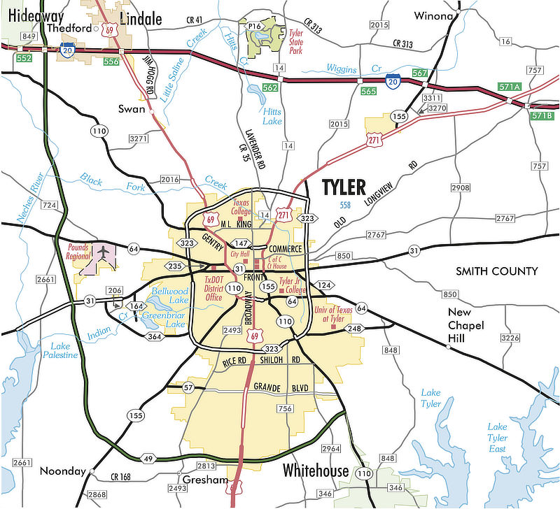
Tyler Texas Area Highway Map from TxDOT (click the map for a larger image at the TxDOT Website)
The Street and Highway System in Tyler
Tyler has an excellent, solid transportation infrastructure which equates to short, easy commuting times and experiences with inner Loop 323 and the new Toll Loop 49. A regional bus system and Pounds Regional Airport provide additional transportation options within and outside of the city.
- U.S. Highway 69 (Broadway Avenue) is the major north-south route through the city, from Lindale south through Tyler down to Bullard and Jacksonville. It is known as North Broadway north of the downtown square, and South Broadway heading south from the square towards Jacksonville.
- Loop 323 functions as a 19.7 mile, ground-level 4-6 lane inner-loop, while the new Toll Loop 49 will provide a large outer-loop at its completion.
- Texas Highway 31 is a major east-west corridor, connecting with Kilgore to the east and Chandler and Athens to the west.
- Texas Highway 64 provides a more northwest-southeast alignment, connecting with Arp and Henderson to the east and Canton to the west.
- Highway 110 to the southeast is also known as "Troup Highway".
- Highway 155 runs to the southwest through Noonday and Coffee City ... also known as the "Frankston Highway".
- U.S. Highway 271 begins in north Tyler and connects with Gladewater and Gilmer to the northeast. Highway 271 provides the shortest access to I-20 when heading east to Longview and Shreveport.
- Farm-to-Market (FM) 2493 travels to Gresham, Flint and Bullard and is also known as "Old Jacksonville Highway".
- Grande Boulevard is a significant east-west route, running from Troup Highway westward, intersecting with Paluxy Drive, South Broadway Avenue and Old Jacksonville Highway, and ending as Texas Highway 57 at Texas Highway 155.
- Paluxy Drive (FM 756) begins near the Green Acres Shopping Center and moves south past Loop 323, Grande Boulevard, and Toll 49. It then crosses FM 346 and continues south outside of Tyler, ending at FM 344 in Walnut Grove.
- Highway 14 runs north from Tyler, past John Soules Food, crosses I-20 and provides access to Tyler State Park.
- Spur 248 (University Boulevard) extends from SSE Loop 323 to the east, and provides access to the University of Texas - Tyler.
- Spur 364 runs from SW Loop 323 and extends to Texas Highway 31 West, and provides access to Lindsey Park.
- FM 346 runs eastward from Flint, passes U.S.Highway 69, Highway 110 in Whitehouse and continues past Lake Tyler.
- Toll Loop 49 is available for those heading westbound to Dallas and beyond from Tyler. Toll 49 currently runs from near Whitehouse westward, crosses I-20, and ends at U.S. 69 between Lindale and Mineola, a total length of 32 miles.
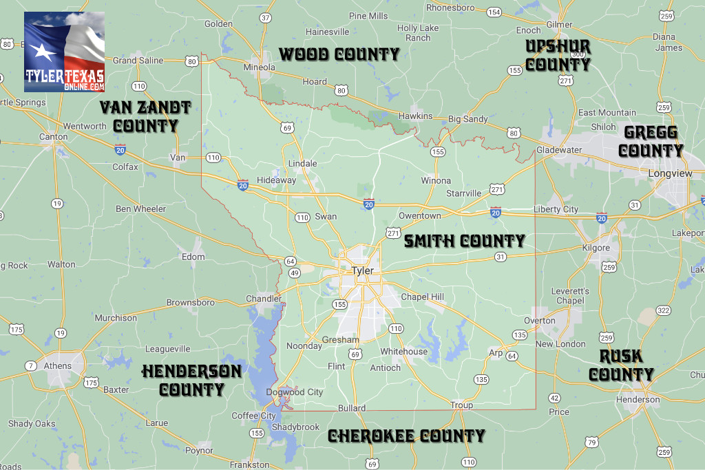
Map of Smith County Cities, Towns and Counties Near Tyler
In addition to Tyler, Smith County contains a number of smaller communities, including Lindale, Winona, New Chaprel Hill, Noonday, Whitehouse, Troup, Arp and Bullard, as shown in the map below. Smith County is outlined in red on the map.
 |
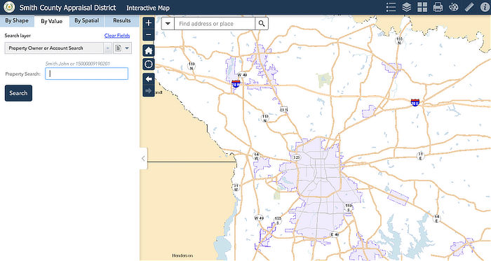
Smith County Appraisal District (SCAD) Map
The Smith County Appraisal District (SCAD) is a political subdivision of the State of Texas responsible for appraising all real and business personal property for the purpose of ad valorem tax assessment on behalf of 24 taxing entities. Additional responsibilities include, but are not limited to: recording property configuration changes, ownership changes, state and local exemptions, maintenance of ownership maps, and furnishing appraisal roll information to the Property Tax Assistance Division of the Comptroller's office.
Visit the website of the Smith County Appraisal District (SCAD) to access the SCAD Interactive Mapping System.
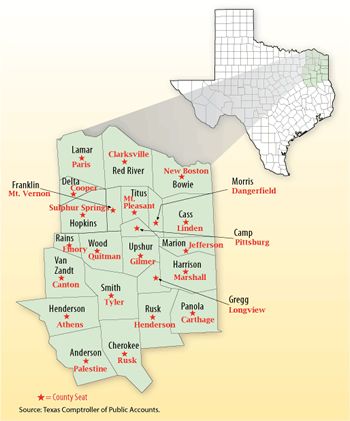
Map of Cities, Towns and Counties in Upper East Texas
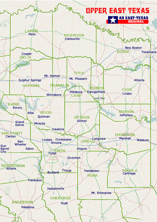
Map of Upper East Texas Counties and County SeatsCourtesy of the Texas Comptroller of Public Accounts |
 |
Interactive Map of Tyler Texas (courtesy of Google Maps)
Other Tyler Texas Mapping Resources
- Smith County Interactive GIS System
- Smith County Map Downloads
- Smith County Appraisal District (SCAD) Interactive Mapping System
- Tyler Visitors & Convention Bureau - Tourist Map
- Map of downtown Tyler and things to do at VisitTyler.com
- City of Tyler - GIS Interactive Map Gallery
- City of Tyler - Lake Tyler Map
- TxDOT Map of the Tyler Area
- NETRMA Toll 49 Map - Current & Planned Segments
- University of Texas at Tyler Map
- Texas College Map
- Tyler Junior College Maps
- Tyler State Park Map
- AnyPlaceAmerica.com - Free printable Smith County, TX topographic maps, GPS coordinates, photos, & more for popular landmarks in Smith County including Tyler, Whitehouse, and Lindale
Smith County Geography
Smith County spreads over 932 square miles of the East Texas Timberlands region, with two-thirds of this environment covered in post oak, blackjack oak, and tall grasses, and one-third is heavily forested with pine and hardwoods.
The soil varies from sandy prairie loams in the northwest and east to loam-covered clay through the remainder of the county.
The elevation ranges from 300 to 600 feet. Mineral resources include petroleum, natural gas, iron ore, clay, limestone, lignite, and salt. Less than 10% of Smith County is prime farm land.
Tyler and surrounding communities are allocated Postal Service Zip Code 75701 - Zip Code 75799. see Tyler Zip Code details and U.S. Post Offices
